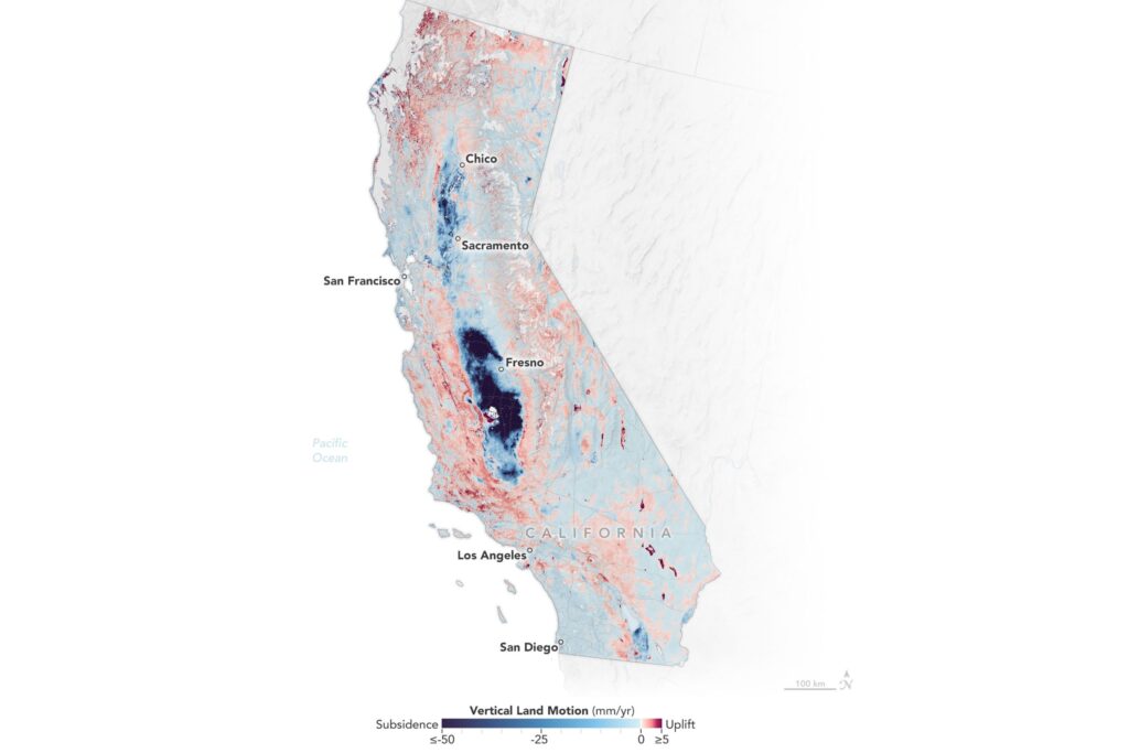
A recent study by a NASA-led team has detailed the areas of California where land is sinking, or rising, the most.
Why It Matters
While NASA’s report said the changes seemed insignificant as they amounted to just fractions of an inch per year, it noted that they can affect local flood risks, wave exposure, and saltwater intrusion.
What to Know
The study examined California’s vertical land motion—both sinking (subsidence) and rising (uplift)—over the period from 2015 to 2023.
Using radar data from ESA’s Sentinel-1 satellites combined with ground-based GPS measurements, researchers from NASA’s Jet Propulsion Laboratory and the National Oceanic and Atmospheric Administration NOAA created detailed maps showing how different areas of the state are changing.
Blue regions on the above map indicate subsidence, with the darker shades sinking at a quicker pace than the lighter ones. Conversely, the dark red regions mark the areas where the land is rising most rapidly.
Both manmade and natural causes were factors in ground level changes.
Many coastal regions, including parts of San Francisco, Los Angeles, and San Diego, as well as sections of the Central Valley, are slowly sinking, it showed.
This was linked to processes such as soil compaction, erosion and groundwater withdrawal.
Land in San Rafael, Corte Madera, Foster City and Bay Farm Island in the San Francisco Bay Area was found to be subsiding at more than 0.4 inches per year, primarily due to sediment compaction—when loose particles are pressed together under the weight of overlying layers. When taking into account the sinking in the lowest-lying areas, local sea levels could rise over 17 inches by 2050.
The fast-sinking land in the state’s Central Valley (up to 8 inches per year) was influenced by groundwater withdrawal, said the report on the study.
“Periods of drought and precipitation can alternately draw down or inflate underground aquifers,” it explained.
In contrast, areas like Long Beach are experiencing uplift. In Long Beach’s case, it was noted that this was a site of oil and gas extraction activities.
What People Are Saying
Marin Govorcin, lead author of the report and remote sensing scientist at NASA’s Jet Propulsion Laboratory, said: “In many parts of the world, like the reclaimed ground beneath San Francisco, the land is moving down faster than the sea itself is going up.”
NASA’s report on the study said: “In coastal areas, understanding local elevation changes can help communities adapt to rising sea levels. The researchers pinpointed hot spots—including cities, beaches, and aquifers—with greater exposure to rising seas in coming decades.”
What Happens Next
A separate study recently suggested that, by 2050, some of California’s biggest cities could be at greater risk from floods than from wildfires.
Do you have a story we should be covering? Do you have any questions about this article? Contact [email protected]
Read the full article here
