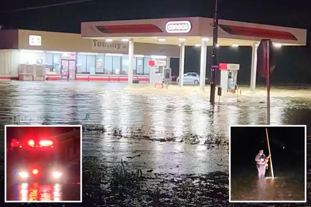
Roads are closed, and first responders are conducting high-water rescues in the San Antonio area after relentless rain in Texas led to reports of deadly flash flooding, with more rounds of heavy precipitation on the way Thursday.
According to information provided by San Antonio Police, first responders were sent to investigate reports of vehicles stuck in high water at the Loop 410 and Perrin Beitel areas just after 4 a.m. local time.
At least one person was pronounced dead, but it’s unclear if the death was caused by a crash or the flooding in the area.
Police said the investigation is ongoing, and more details would be provided once received.
However, according to an initial report from FOX San Antonio KABB, three people were killed after a multivehicle crash.
KABB reported that police said one person was killed in the crash, and two bodies were found downstream after being swept away by floodwaters.
In addition, several vehicles were reported to have been swept away, and first responders are working to recover the missing vehicles.
“In San Antonio proper, we’ve picked up over 5.5 inches of rain in three hours,” FOX Weather Meteorologist Britta Merwin said. “These are very aggressive rain rates.”
In total, San Antonio picked up about 6.62 inches of rain over the past two days, with 6.12 inches falling over the past day. This makes Thursday the wettest day in San Antonio in 12 years, nearly doubling the city’s previous daily record of 3.26 inches set in 1973.
It’s also San Antonio’s 10th-wettest day overall since records began in July 1885.
More than 3 inches of rain fell in the New Braunfels area, northwest of San Antonio, in 30 minutes. A video recorded in Santo, Texas, shows significant flooding taking place as the heavy rain fell.
Another video showed first responders rescuing residents from flooding conditions on Panama Road. Officials said water as high as 4 feet was reported in some areas, with “water flowing swiftly in most areas.”
As of early Thursday morning, the San Antonio Fire Department had responded to about 20 high-water rescues, and countless roads were closed due to flooding.
The National Weather Service said 40 low-water crossings were closed in Bexar County, along with several others in Comal and Hays counties.
In addition, Leon Creek at Loop 410 near Leon Valley in the San Antonio area rose sharply by 13 feet in two hours and had more than 41,000 cubic feet of water per second flowing through it.
“It’s incredibly important not to travel,” Merwin continued. “San Antonio does have a robust system where they close roads, especially in these lower-level parts of the interstate.”
Flooding has also been reported in Houston. FOX Weather Correspondent Katie Byrne was in Houston on Thursday morning and shared video of high water in the Lake Houston Forest neighborhood.
The FOX Forecast Center said the heavy rain and severe weather threat that began Tuesday in Texas is likely to continue through at least the rest of the workweek.
A moist atmosphere, with moisture levels running well above average for early June, is what’s contributing to the threat, with strong instability and plentiful storm energy aiding in severe thunderstorm development.
As winds remain light in the atmosphere, storms that develop will be slow-moving, thus producing high rainfall totals and increasing the flood potential.
The FOX Forecast Center said that a stalled cold front will act as a focus point for rounds of heavy rain and storms through the rest of the week, including in areas of the Red River Valley that are already quite saturated from historic rain earlier in the spring.
The flood threat will shift to the east, putting the Ark-La-Tex region at risk on Thursday. This includes cities from Houston to Little Rock in Arkansas.
On Thursday, NOAA’s Weather Prediction Center (WPC) placed the Houston area in a Level 3 out of 4 threat of flash flooding, with the threat shifting into Arkansas on Friday.
Most of the state has been placed in a Level 2 out of 4 flash flood threat.
Severe weather is also a concern on Thursday. NOAA’s Storm Prediction Center (SPC) placed a large portion of Texas and the Deep South in a Level 1 threat on its 5-point severe thunderstorm risk scale.
This includes cities like Corpus Christi, Houston and Lufkin in Texas, Lake Charles, Alexandria and Shreveport in Louisiana and Jackson in Mississippi. Storms are also possible in the Memphis area on Thursday.
Upper Midwest also faces flood threat Thursday
Flooding and severe weather are also a concern in the Upper Midwest on Thursday.
The FOX Forecast Center said an upper-level disturbance continues to move into the region from Canada, allowing for an area of low pressure to develop as a cold front drapes across Minnesota.
As the front slows and retreats to the north, more energy advancing out of the Dakotas is expected to move along with it into Minnesota. The low-level jet stream will help to funnel in moisture originating from the Gulf, hundreds of miles to the south.
That setup will allow for a period of heavy rain across portions of central Minnesota, southeastern North Dakota, northeastern South Dakota and extreme western Wisconsin.
The WPC placed the region in a Level 2 out of 4 threat of flash flooding on Thursday.
This includes the Minneapolis-Saint Paul area.
Severe weather is also possible across the region, with the SPC placing areas of Nebraska and South Dakota in a Level 2 out of 5 threat.
A Level 1 threat extends from Colorado to southern Minnesota and northern Iowa.
Read the full article here
