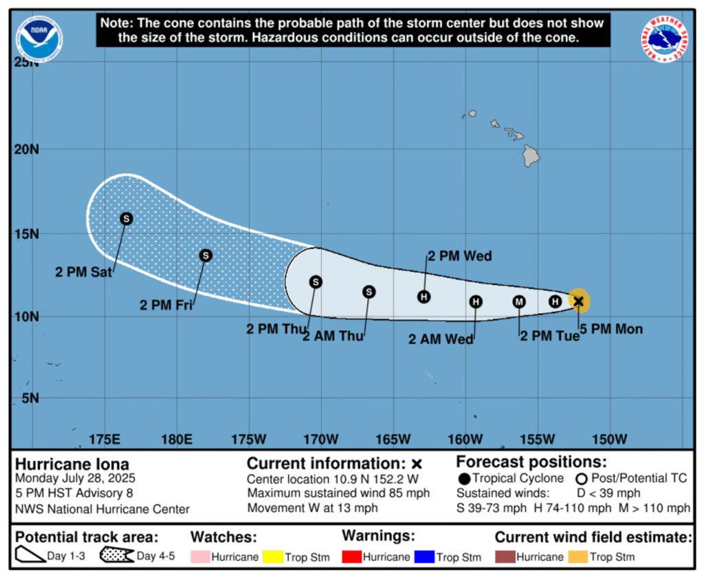
Hurricane Iona has rapidly strengthened in the Pacific Ocean well south of Hawaii, according to the National Hurricane Center (NHC).
At present, Iona doesn’t pose a threat to Hawaii
Why It Matters
It marks the first hurricane in the central Pacific Ocean this year.
What To Know
“Maximum sustained winds are near 85 mph (140 km/h) with higher gusts,’ the NHC said on Monday. “Rapid strengthening is forecast tonight with Iona expected to become a major hurricane on Tuesday. Steady weakening is expected to begin by Wednesday.”
As of Monday evening, Iona was located about 810 miles south-southeast of Honolulu, and was moving west across open waters. The storm was packing maximum sustained winds of 85 miles per hour.
No coastal watches or warnings have been issued. The NHC noted that there are currently no hazards affecting land.
Forecasters expect Iona to intensify rapidly overnight and reach major hurricane status—defined as Category 3 or higher—by Tuesday. Peak strength is anticipated Tuesday night into early Wednesday, with maximum sustained winds projected to reach 120 miles per hour.
Hurricane-force winds extended outward up to 15 miles from the center, and tropical-storm-force winds reached up to 60 miles.
After peaking, Iona is forecast to begin a steady weakening trend starting Wednesday as it continues on a westward path across the central Pacific.
The Central Pacific hurricane season began on June 1, as did the Atlantic season, two weeks after the Eastern Pacific season, which started on May 15. Each hurricane season runs through November 30.
What People Are Saying
Ryan Maue, meteorologist, said on X: “In the past few hours, Hurricane Iona, well south of Hawaii, has continued to rapidly intensify in the tropical Central Pacific. A clearing eye = Category 4 satellite intensity estimates.”
Alex Boreham, tropical meteorologist, said on X: “Very impressive intensification tonight with #Iona. Well on the way to becoming a major hurricane. We’ll see if it can keep overshooting the forecast before it starts to feel shear tomorrow.”
Andrew Austin-Adler, a student meteorologist specializing in tropical cyclones, said on X: “Strongest CPAC hurricane since WALAKA is inbound. Iona is on the fast track to reaching major hurricane strength – official forecast is 120mph which could be conservative.”
Andy Hazelton, associate scientist at the University of Miami CIMAS, said on X: “#Iona is a small but impressive hurricane. Goes to show that hurricanes are mesoscale to synoptic systems, and can sometimes form even if the seasonal factors…make them less likely. Reminds me of Atlantic hurricanes Danny (2015) and Beryl (2018), which formed in the MDR [Managed detection and response] despite the MDR being generally hostile for most of the year.
What Happens Next
The next full advisory from the NHC will be issued at 11 p.m. HST Monday.
Read the full article here
