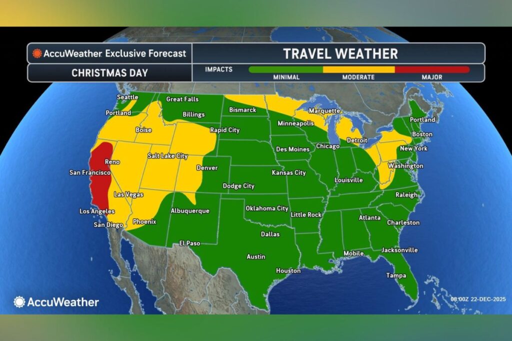
Travel maps issued by forecasters at AccuWeather show which U.S. states could see the most pronounced Christmas travel impacts this week.
According to the outlet, storms and slick conditions may cause disruptions for millions across large parts of California, the Great Lakes region, and the interior Northeast ahead of Christmas Day.
A forecast map from AccuWeather for Wednesday shows that the states facing major travel impacts are much of California, western Nevada, central Washington and Oregon, as well as portions of Idaho and Montana.
States that can expect “moderate” impacts on Wednesday include Wyoming, Utah, Colorado, Arizona, New Mexico, Iowa, Indiana, Kentucky, Illinois, and Maine. The majority of the remainder of the U.S. would see minimal impacts this day, according to AccuWeather’s map.
For Christmas Day, only California faces major travel impacts, a map for Thursday shows. Meanwhile, moderate impacts are forecast for the following states:
- Oregon
- Washington
- Idaho
- Wyoming
- Utah
- Nevada
- Arizona
- Colorado
- North Dakota
- Minnesota
- Wisconsin
- Michigan
- Ohio
- Pennsylvania
- Kentucky
- New York
Minimal travel impacts are anticipated for the most of the remainder of the Lower 48, the map shows.
In an advisory shared with Newsweek on Monday, AccuWeather forecast a “quick-hitting” storm to move over the Great Lakes area Monday and into Tuesday.
“A period of freezing rain can mix in with snow and sleet Monday night into Tuesday across portions of central and south-central Pennsylvania, resulting in a stretch of potentially hazardous holiday travel,” AccuWeather meteorologist Alex DaSilva said in the advisory.
“Travelers taking to the roads later Monday night or Tuesday morning should heed any roadway restrictions or warnings in place and give themselves extra time to reach their destination.”
The storm’s core is expected to move through New York and New England on Tuesday, followed by lingering drizzle and snow showers. Snow accumulation is likely in parts of northern Pennsylvania, upstate New York, and New England, with higher elevations—including the Adirondacks, Green and White Mountains, and southern Maine—potentially seeing three to six inches of snow, according to the outlet. However, temperature increases ahead of Christmas Day could melt much of the snow outside of higher elevations, it added.
A second storm is forecast to move through the Ohio Valley, Northeast, and mid-Atlantic from Christmas Eve into Christmas morning, bringing widespread rain and the chance of snow or a wintry mix in some higher elevations, AccuWeather said.
Meanwhile, the outlet anticipates the heaviest Christmas travel impacts to be felt in the western U.S.
An atmospheric river will focus on northern and central California through Wednesday, with another expected to hit central and southern parts of the state Tuesday through Christmas Day, according to the outlet.
These are “relatively long, narrow regions in the atmosphere—like rivers in the sky—that transport most of the water vapor outside of the tropics,” the National Oceanic and Atmospheric Administration explains.
Two to four inches of rain is possible in the San Francisco Bay Area through Friday, with four to 12 inches likely on west- and southwest-facing portions of the Coast Ranges and Sierra Nevada through Wednesday, the outlet said, adding that the second atmospheric river is forecast to bring four to eight inches of rain to the Los Angeles area through Friday.
Showers could also reach Las Vegas and Phoenix this week, AccuWeather said.
Read the full article here
