


Updated ,first published
The cyclone heading towards Queensland has strengthened and sped up as it approaches the coast, with evacuations now underway and the luxury Lizard Island Resort shut down.
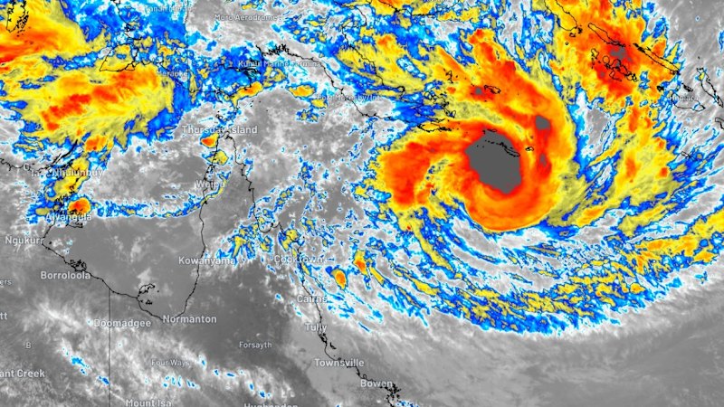
Tropical Cyclone Narelle is threatening to develop into a category 5 system and could be one of the biggest cyclones “in living memory”.
An update from the Bureau of Meteorology on Wednesday afternoon said winds near the centre were measured 120 kilometres per hour, having developed from a category 2 into a category 3 over the Coral Sea.
The BOM added very destructive winds of more than 250 kilometres per hour were possible near the centre as it crossed the coast, likely on Friday morning between Lockhart River and Port Douglas.
Narelle’s approach towards the coast had sped up from 18 kilometres per hour to 22 kilometres per hour.
“This may be the biggest system that many people have seen in living memory,” Queensland Premier David Crisafulli warned on Wednesday.
“The situation is evolving. It’s a serious situation, and the window to act is obviously closing.”
It is the third system to impact the sodden Queensland region in barely two months after two lows struck, causing widespread flooding.
Narelle is the biggest to hit the far north since category 4 system Cyclone Debbie devastated the Whitsundays in 2017, causing billions of dollars in damage.
Last year, ex-tropical cyclone Alfred crossed the coast just north of Brisbane on March 8.
More than 100 emergency personnel, including swift water rescue teams and 49 police officers from Brisbane and Cairns, have been deployed north as locals batten down the hatches.
“This is not the opportunity for you to be outside during the cyclone, getting that TikTok moment – do not do it,” state disaster coordinator Chris Stream said.
“A piece of debris being propelled at over 100km/h will kill you.”
Lizard Island Resort has been effectively shut down and emptied, the premier said, with 10 people remaining who were sheltering in a “strengthened area”.
Four people have also been evacuated from Port Stewart, located on the mainland near Coen.
Crisafulli urged other residents in the region to also consider evacuating on Wednesday.
“The best time to move is today,” he said.
He said there was a “real prospect that it will remain a cyclone as it crosses what is a very narrow part of the state”.

Twenty-two schools in the cyclone’s strike zone remained open on Wednesday.
Senior meteorologist Christie Johnson said the storm would cross over a period of about 12 hours, and was expected to strengthen.
Johnson said she would be “very surprised” if the cyclone significantly weakened, given the weather conditions currently feeding the system.
Another senior bureau meteorologist, Jonathan How, said heavy rainfall was also expected, causing flash flooding and a dangerous storm tide.
“As the system crosses on Friday morning we are expecting those very destructive wind gusts of more than 225km/h,” he said.
“We are expecting to see property damage, roofs being torn off houses and businesses as well as trees being stripped and power lines cut down.”
Wind gusts up to 155km/h could start buffeting coastal towns between Coen and Cooktown from as early as Thursday night.
Buildings and houses constructed in the region after 1982 should be built for a category 5 cyclone rating and able to withstand the storm.
“[It] is really important that people know … the risks of their own structures,” Deputy Commissioner Chris Stream said, adding that police may be unable to fly rescue aircraft for eight to 10 hours after the cyclone hits due to safety reasons.
Modelling had earlier indicated the cyclone could “wobble a bit” as it approached the coast, but Johnson said uncertainty in the system’s track now centred on its path from east to west, which would affect how quickly the storm moved to the coastline.
“Our modelling that’s come in overnight has slowed it a little bit, so it’s pushing it more towards it being well into Friday,” Johnson said.
“The earliest that we’d be expecting it might reach the coast would be Thursday afternoon or evening.
“Of course, we’ll start to see impacts before it actually reaches the coast.”
The weather bureau said the system could also push thunderstorms down the Queensland coast as far as Ingham and northern parts of Townsville, impacting already sodden parts of Queensland further inland.
with AAP
Start the day with a summary of the day’s most important and interesting stories, analysis and insights. Sign up for our Morning Edition newsletter.
From our partners
Read the full article here


