

")


A high-impact and potentially historic winter storm is underway, delivering heavy snow, crippling ice, and days of life-threatening travel conditions to more than 245 million people from Arizona to Maine through the weekend.
All told, the storm will stretch across a 2,300-mile path covering more than 40 states from the Southwest into New England, delivering a blend of harsh winter weather impacts.
More than 190 million Americans are under Winter Weather Alerts.
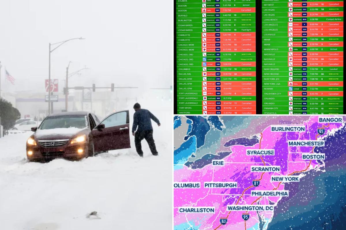
Travel has already slowed to a crawl across major transportation hubs, with nearly 10,000 flights canceled nationwide through Monday.
Meanwhile, nearly 230,000 customers were left without power in the south as the storm raged across the Midwest and up the East Coast early Sunday morning.
The states with the most reported power outages were Mississippi at over 75,000, Louisiana at 68,000 and Texas at nearly 67,000, Poweroutage.us.
The sprawling system has already reached parts of the Midwest and Ohio Valley.
States of emergency have already been declared in 21 states, including Arkansas, Louisiana, Mississippi, Alabama, Tennessee, Georgia, South Carolina, North Carolina, Missouri, Kansas, Kentucky, West Virginia, Ohio, Virginia, Maryland, Delaware, Pennsylvania, New York, New Jersey, Indiana, Connecticut and Washington DC.
President Donald Trump said on social media that the Trump administration is coordinating with both state and local officials ahead of the winter storm and that the Federal Emergency Management Agency (FEMA) is fully prepared to respond.
The storm had already made history before any flakes flew on Friday, breaking the record for the highest number of counties simultaneously under a Winter Storm Warning.
Formation of the storm
The sprawling system began to develop midday Friday in the Plains, arriving a little before computer forecast models, and started dumping snow, ice and rain as it began its journey across the country.
Hays, Kansas recorded 6 inches of snow as of early Saturday morning, while 3 inches was tallied in Norman, Oklahoma over that same period.
Heavy snow is expected to continue between Interstates 70 and 40 in the Plains through Saturday.
Models continue to put the heaviest snow from just north of Oklahoma City into portions of central Kansas where over a foot of snow is possible.
Elsewhere, a wide swath of 5 to 8 inches of snow looks likely to occur, especially in areas from Amarillo north into Kansas City.
Widespread icing from Midland, Texas, to Dallas and Little Rock is likely throughout most of Saturday, sufficient to cause numerous power outages and severely disrupt travel along major interstates such as I-20 and I-35 into Sunday.
Into the Southeast
The high-impact storm is beginning its trek towards the Southeast and will kick off the weekend with crippling ice and snow for millions.
From Mississippi into parts of the Carolinas, power outages will become increasingly likely as Ice Storm Warnings are scattered across the region.
The heaviest accumulations are expected to focus on Arkansas, northern Mississippi, and western Tennessee, a corridor that includes Little Rock, Arkansas, Oxford, Mississippi, and Memphis, Tennessee, where up to 0.75 inch of ice is forecast, and over an inch of ice in some localized areas is possible.
Within the affected regions, ice accumulation is expected to cause crippling impacts on both power infrastructure and travel.
Widespread power outages are likely as the weight of the ice compromises lines and topples trees.
The highest snow totals in the Southeast will be confined to areas along and north of I-40, mainly across Kentucky, which is expected to see significant snow statewide, with totals of 5 to 8 inches. An impressive swath amounting to up to a foot of snow, stretching from border to border, is possible.
Nashville remains on the edge of the transition zone and could see all snow, a wintry mix or rain.
The higher elevations of middle Tennessee, into east Tennessee and the Smoky Mountains will still see snow totals on the higher end with 3 to 5 inches possible.
Major city snow
It has been a decade since a foot or more of snow fell in cities like Washington, DC, Baltimore and Philadelphia, and five years since New York City saw more than a foot.
There are streaks that could be coming to an end as this historic storm has its sights on bringing major snow across the Mid-Atlantic, Northeast and the I-95 corridor starting Saturday as the storm moves in from the west.
As the sun rises Sunday morning, snow will be falling from northern Virginia into the New York tri-state area, and it will continue to dump snow and strengthen through the day Sunday, with peak snow rates potentially reaching 2 to 3 inches per hour.
The best chance of the heaviest accumulations are north and west of DC along I-81 through Pennsylvania, across I-80 into the tri-State area including New York City, northward into the Hudson Valley, spreading east across southern New England into Boston, where 18 to 24 inches of snow is possible.
As heavy snow chances of over a foot have decreased in Roanoke, Richmond, Washington, DC, and Philadelphia, current forecasts favor New York City, where 8 to 12 inches of snow is possible.
Another region that could see the “jackpot” in terms of snow totals will be coastal Massachusetts, banking on ocean enhancement of snow bands.
Heavy snow looks likely to set up from the North Shore of Massachusetts and extend down into the northern Cape. A widespread 12 to 18 inches of snow is likely with locally higher amounts possibly closer to two feet.
Preparations underway
Ahead of the storm, Americans across the country have prepared for the major storms by raiding local supermarkets as heavy snow and ice accretion make for dangerous travel conditions.
Shelves were empty in grocery stores from Texas to New York.
Energy companies have already begun mobilizing additional crews to prepare for ice accretion, known to be capable of taking down power lines and creating impossible driving conditions.
Frigid temperatures lock in winter weather impact
While current forecasts suggest that the storm will wind down Monday from west to east as the area of low pressure pulls away from the coast, the cold weather will stick around for millions of Americans, prolonging impacts for areas affected by ice and snow.
A powerful arctic high is driving exceptionally dense, bitterly cold air deep into the Lower 48. This arctic air mass will then dominate the entire weather pattern through the weekend and will play a key role in the development of the historic winter storm across the South and the East Coast.
Extreme Cold Warnings and watches now extend across much of the Upper Midwest, Plains and into the Northeast.
Major cities included in these alerts range from Minneapolis and Detroit to Boston and New York City. Farther south, locations such as Oklahoma City, Dallas and Little Rock are also under Cold Weather Alerts through the weekend.
Along the East Coast, temperatures will struggle to rise above freezing through the weekend. Cities such as New York City may see highs only in the teens by Sunday, with wind chills making it feel closer to the single digits as more than 260 million Americans will experience below-average temperatures, and over 50 million could see readings drop below zero.
Parlayed with the threat of power outages, frigid temperatures are yet another factor in the multi-threat storm that people should be aware of as the storm unfolds in the coming days.
Read the full article here


