


Parts of Western Australia’s Pilbara region have been battered by the outskirts of Tropical Cyclone Narelle as it moved out to sea to strengthen into a category 4 system before its predicted coastal crossing at the weekend.
Fierce wind and rain has already been seen across the mining hubs of Port Hedland, Dampier, Karratha and the tourist town of Exmouth along the Pilbara coast, with wind gusts reaching a high of about 150km/h off Bedout Island on Thursday morning.
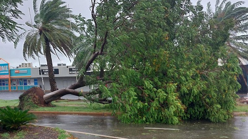
Trees have fallen over and power is out in parts of Exmouth and Dampier, and the City of Karratha issued a warning to residents as the system passes through.
“We’re seeing trees down, debris on roads and water moving through drains and waterways due to current weather,” a statement said.
“Please stay alert and take extra care … our crews will respond as soon as it is safe to do so.”
An evacuation centre has set up at Exmouth Shire Hall, and those on Barrow Island and the Montebello Islands have been told to shelter in place.
The Bureau of Meteorology forecaster Ilana Cherny said while the Pilbara was already experiencing intense conditions, Narelle would only get stronger throughout Thursday.
The damaging winds will continue for Exmouth and the North West Cape before the system travels down the coast towards Shark Bay, Denham, Carnarvon, Kalbarri and Geraldton, along the Mid West and Gascoyne coasts.
The cyclone continued to track south-west offshore and used its time at sea to intensify again into a category 4 system, and emergency services have warned favourable conditions could even see it turn into a category 5.
The Pilbara Ports Authority said it was preparing for the worst-case scenario.
“A period of rapid intensification is likely during the next 30 hours, and the chance of Narelle reaching category 5 intensity while north of the Pilbara coast is around 30 per cent,” a statement said.
“The extent of gales and storm force winds south of Narelle is likely to be larger than normal. Sustained gales are occurring over coastal parts of the Pilbara, with storm force winds just offshore.”
Pilbara Ports has closed the ports of Ashburton, Cape Preston West, Dampier and Varanus Island as a precaution, and warned all recreational users they were responsible for their own vessels as the storm passed through.
Many mine sites have activated emergency protocols to keep their workers safe, and a Chevron Australia spokesperson said they were prepared for the cyclone, with Barrow Island – home to the company’s Gorgon LNG project – almost directly in the system’s path.
“We are implementing our cyclone preparation plans at the Gorgon and Wheatstone natural gas facilities, and on the Wheatstone platform,” the spokesperson said.
“Non-essential personnel have been demobilised from our facilities, with remaining personnel relocated to purpose-built cyclone-rated accommodation facilities while the cyclone passes off the coast.
“Domestic gas and LNG production continues at the facilities.”
Some shopping centres, restaurants, cafes and retail outlets across Karratha and Port Hedland have reduced their hours or closed as the system heads over.
A Perth Airport spokeswoman said there had been about 38 flights to WA’s north cancelled as of Thursday morning due to the cyclone.
The Department of Education has also closed more than a dozen schools in the Pilbara as a precaution.
As the cyclone tracks south, residents from Kalbarri to Geraldton are preparing.
“We are looking at a coastal crossing sometime on Friday evening or Friday night,” Cherny said.
“It looks [like it will cross] about the Gascoyne coast, somewhere between Coral Bay and Kalbarri – with the Denham area looking like the most likely scenario.
“We are expecting this system to cross as a category 3 severe tropical cyclone.”
Kalbarri visitors warned to get out
Kalbarri does not have a dedicated evacuation shelter after plans to establish one following the 2021 disaster of Cyclone Seroja consistently fell over.
The Shire of Northampton advised on Thursday all tourists and visitors needed to leave the town as soon as was practical.
“All visitors are being urged to depart today,” the statement said.
“From Friday 27 March, the Department of Fire and Emergency Services have advised that townsites in the Shire of Northampton, including Kalbarri are likely to be moving to a Red Alert.
“Road closures are anticipated from Friday morning, with no access north of Jurien Bay. Travel south will remain open during this period.
“All travellers are advised to relocate to areas south as soon as possible.”
Some residents have already begun evacuating the town as well, heading south to ride out the system in Perth.
An emergency flight has also been scheduled by regional airline Rex to help people leave Denham on Thursday afternoon, which is in the cyclone’s direct path.
Start the day with a summary of the day’s most important and interesting stories, analysis and insights. Sign up for our Morning Edition newsletter.
From our partners
Read the full article here


