


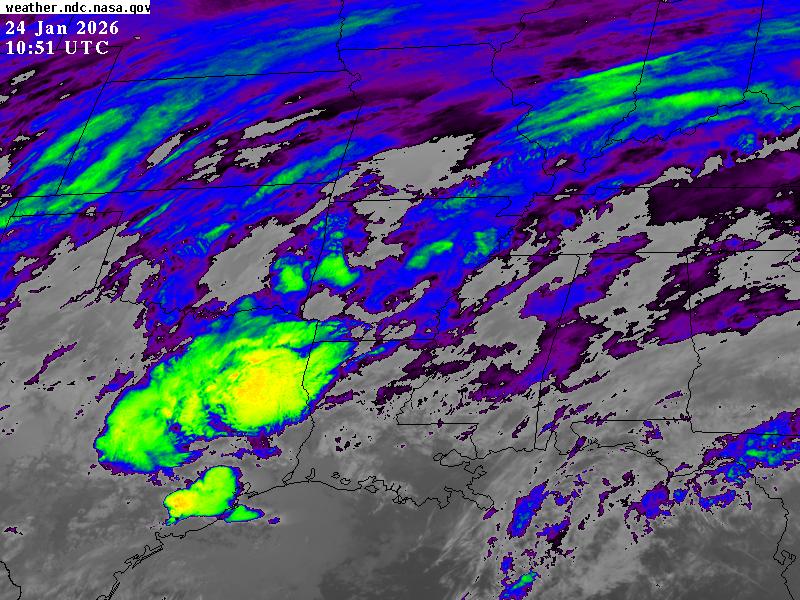
Satellite imagery from NASA shows widespread winter weather affecting parts of the United States, with snow and cold weather spreading across the Great Lakes region and beyond.
A powerful and widespread winter storm is moving across the United States, bringing heavy snow, ice, freezing rain, and dangerously cold temperatures to large parts of the country.
The storm began in the southern Plains and Rockies on January 23 and is now affecting nearly half of the nation as it continues eastward. Snow has already fallen in places such as Texas and Oklahoma, and the storm is expected to push into the Midwest, Great Lakes region and the Northeast over the coming days.
The system is being driven by a strong surge of Arctic air from Canada meeting warmer, moist air from the south, leading to significant weather impacts across a broad area.
The National Weather Service (NWS) has issued two advisories warning people to avoid travel while the winter storm affects large parts of the country. These warnings cover millions of Americans and are expected to disrupt travel plans this weekend, forcing many to make unexpected changes to their schedules.
The NWS has emphasized that the storms pose a threat to life and property and could cause widespread and long-lasting power outages.
NASA satellite imagery shows the storm’s extensive cloud cover and development in near real time. These satellites provide continuous views of the storm’s progression, capturing features such as thick cloud bands associated with the low‑pressure system.
The imagery is helping scientists and forecasters track the movement and evolution of the storm, as well as identify areas where precipitation is most intense.
Satellite image captured the Great Lakes region showing a broad layer of snow on the ground and newly formed lake ice following a potent winter system.
In western Michigan, portions of the state received significant snowfall in the days before the image was taken, with some locations reporting nearly a foot (around 30 cm) or more of snow, according to the NWS. Blizzard conditions were reported in parts of Ontario east of Lake Huron.
More than a dozen states and the District of Columbia have declared states of emergency in anticipation of dangerous conditions. Winter storm warnings cover a swath of the country from New Mexico through New England, and roughly 140 million people are under alerts for heavy snow, sleet, ice, and bitter cold.
Officials are warning that some areas could see snowfall totals exceeding a foot, while others could experience significant ice accumulation that makes travel dangerous. Bitterly cold wind chill values are expected to accompany the storm, increasing the risk of frostbite and hypothermia for anyone exposed to the elements for extended periods.
The storm has already disrupted travel and infrastructure. More than 8,000 flights have been canceled across the United States, affecting major airports and travel hubs.
Rail companies have warned of delays and disruptions, and transportation agencies are preparing road treatments and mobilizing crews to respond to snow and ice.
Power companies and emergency services are also preparing for the possibility of outages as ice accumulates on power lines and winds increase. Residents are being urged to avoid non‑essential travel, keep supplies on hand, and follow guidance from local authorities.
Read the full article here


