



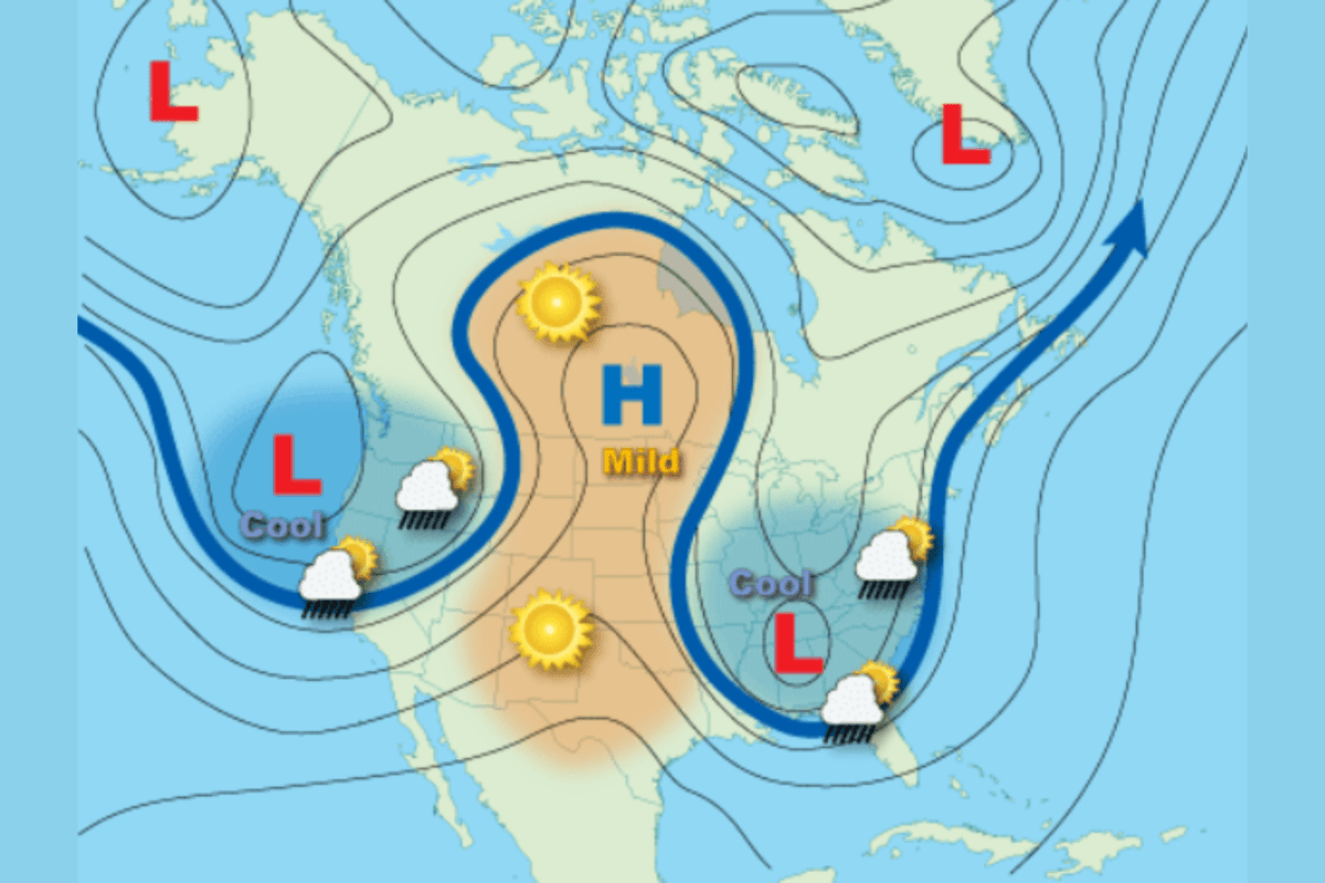
A powerful atmospheric pattern known as an “omega block” is currently locking weather across the United States into place, creating a patchwork of heat, storms, and unusually persistent conditions from coast to coast.
What Is an Omega Block?
An omega block is a large-scale weather pattern named for its resemblance to the Greek letter Ω.
According to the National Weather Service (NWS), it forms when a strong high-pressure system becomes sandwiched between two low-pressure systems, forcing the jet stream into a curved, looping shape.
Under normal conditions, the jet stream carries weather systems steadily from west to east. But during an omega block, that flow becomes disrupted—creating what meteorologists often describe as an “atmospheric traffic jam.”
The result is a pattern that can stall for days or even weeks, causing the weather in each region to change very little over a period of time.
Why It Happens
Omega blocks develop when the jet stream’s wave-like motions—known as Rossby waves—become highly amplified. This can cause the flow to buckle dramatically north and south, eventually isolating areas of high and low pressure.
Weaker steering winds, temperature contrasts in the atmosphere, and seasonal transitions (especially late spring and summer) can all contribute to these slow-moving, locked patterns.
How It Affects US Weather
The defining feature of an omega block is that it creates distinct weather zones across the country:
Central U.S. (Plains & Midwest): Heat and Dry Conditions
States across the central U.S.—including Texas, Oklahoma, Kansas, Nebraska, the Dakotas, and parts of the Midwest—all sit under the high-pressure ridge.
- Expect above-average temperatures, sometimes 15-25 F higher than normal.
- Conditions are typically dry and sunny, with limited storm activity.
South and Southeast: Storms and Flood Risk
The southern flank of the pattern often becomes a focus for moisture.
States such as Louisiana, Mississippi, Alabama, Georgia, and Florida can see repeated rounds of rain and thunderstorms. Rainfall can often accumulate over several days, raising the risk of flash flooding.
East Coast and Northeast: Cooler, Unsettled Weather
Along the East Coast, low pressure can bring persistent unsettled conditions.
New York, Pennsylvania, New Jersey, and New England may experience cooler-than-normal temperatures with cloudy skies.
Periodic storms might linger, creating a prolonged stretch of damp weather.
West Coast and Northwest: Wet and Stormy
Another low-pressure system often parks over the West.
Washington, Oregon, California, and parts of the Rockies may see rain, gusty winds, and even late-season mountain snow.
Storm systems can repeatedly track through the same areas, increasing precipitation totals.
How to Prepare
Because omega blocks prolong conditions rather than intensify them quickly, preparation depends heavily on location:
In hot, dry regions (central areas):
- Stay hydrated and limit outdoor activity during peak heat
- Monitor for heat advisories and drought conditions
In storm-prone regions (the South):
- Watch for flash flood warnings and severe thunderstorm alerts
- Avoid flooded roads and check drainage around homes
In cooler, wet regions (the East and Northwest):
- Plan for prolonged rain and travel disruptions
- Be aware of localized flooding or landslides in vulnerable areas
Read the full article here


