


The cold air settling over the Greater Toronto Area is likely to remain for the rest of the month as Arctic air seeps into the region, creating another “polar vortex.”
Temperatures have plummeted in many parts of the GTA, with Toronto seeing -13 C, but with the wind chill, it’s feeling more like -24. In Vaughan, the wind chill is making -13 C feel more like -19, and in Oshawa, it feels closer to -22 C.
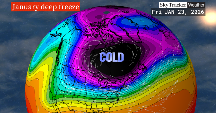
“You often hear about the polar vortex, and that’s really oftentimes where some of the coldest air is centred around the Arctic Circle and farther north and at times parts of it can travel south,” said Global News meteorologist Ross Hull. “We get into these Arctic air events, or intrusions as some people call them, and that’s what we’re experiencing right now.
“It does look like this pattern is going to stay put for at least the rest of January, which I know is not necessarily welcome news for some people.”
Hull said over the final two weeks of the month, temperatures will likely sit a few degrees below normal as a trough of cold air “sticks around” until the start of February.


Get daily National news
Get the day’s top news, political, economic, and current affairs headlines, delivered to your inbox once a day.
There will be a brief reprieve from the extreme cold on Wednesday, though, when an Alberta clipper rolls through the region.
According to Hull, the clipper will briefly move to the south into the U.S. before hitting Toronto, bringing a southerly push of air, taking the temperature closer to zero.
“So temperatures actually rise, but does deliver some snow,” Hull said.
He added that the clipper won’t bring snow to the levels seen last week, with closer to five centimetres falling. Some lake “enhancement” could be seen in the east end of the GTA, with Scarborough and southern Durham possibly seeing closer to eight centimetres.
The break will be short-lived, however, as Environment Canada is forecasting temperatures in GTA cities to begin dropping again on Thursday, with Toronto hitting -4 and -11 C on Friday and Saturday. Hull cautioned that wind chills on Friday night and Saturday morning could hit the -30s.
As the temperatures dip, various communities, including Toronto, Durham and Peel Region, have opened warming and emergency shelters for people needing a place to stay.
Environment Canada has not issued an extreme cold alert for the GTA as of Tuesday afternoon, but those are typically issued only when the temperature or wind chill is forecast to reach -30 C for at least two hours.
While a warning is not in place, Environment Canada cautions that when the temperature drops below zero, health issues can still occur, including frostbite or windburn.
People are reminded to wear appropriate clothing, to keep moving when outdoors to maintain body heat and to check the weather conditions before leaving home.
Read the full article here


