


The National Hurricane Center (NHC) has warned that Tropical Storm Erin could move, causing impacts to Puerto Rico, the Virgin Island and the northern Leeward Island over the weekend, though the agency said the magnitude of any potential impacts was unclear.
Why It Matters
Meteorologists have indicated that Erin has the potential to become the first major hurricane of the 2025 season.
Eris is the fifth named system of the Atlantic season so far, following Andrea, Barry, Chantal, and Dexter. Chantal brought heavy rain and flooding to North Carolina in early July.
None of the previous named storms developed into hurricanes.
What To Know
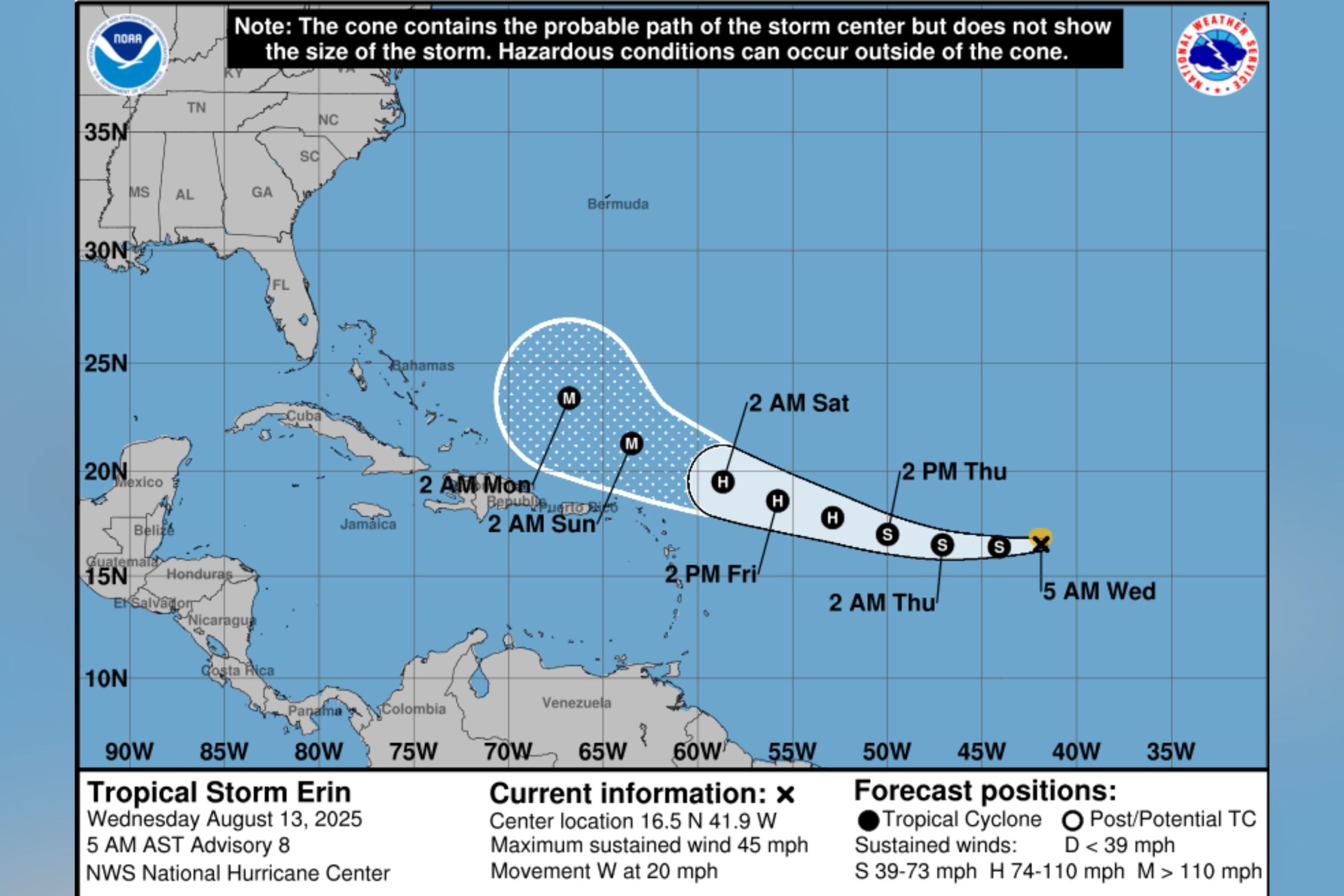
In a video update posted to social media on Tuesday, NHC warning coordination meteorologist Robbie Berg said that Erin was located over the eastern Atlantic and was expected to move west and strengthen into a hurricane, potentially moving to the north of the Leeward Islands.
“The track forecast has shifted a bit to the south. That does potentially increase the risks to the islands as we head into the weekend,” Berg said.
“We now have about a 25 to 30 percent chance of tropical storm-force winds on some of those islands. So now is the time to start thinking about getting some supplies ready just in case the storm is to move a little bit closer.”
NHC said there was “even greater uncertainty” regarding any potential impacts to the Bahamas and the east coast of the U.S.
In its most recent public advisory for Tropical Storm Erin, NHC said the system was moving west at around 20 miles per hour, with maximum sustained winds near 45 mph.
The agency said Erin was “likely” to become a hurricane by late Thursday or early Friday.
What People Are Saying
Meteorologist Brooks Garner said in a post on X, formerly Twitter, on Wednesday: “Tropical Storm Erin continues to battle Saharan Dust slowing its development. It’s now expected to become a hurricane a day or two later than initially forecast, but it’s still expected to become a ‘Major’ Cat 3. Models persist it will curve out to sea next week.”
ABC7 New York meteorologist Brittany Bell said on X, Wednesday: “Here’s the latest track for Tropical Storm Erin. The latest trends continue to show it curving north in the Atlantic, but it will bring rough surf and rip currents next week along our coastline.”
What Happens Next
The Atlantic hurricane season runs from June through November, while the eastern Pacific hurricane season began on May 15 and lasts until November 30.
NHC says that August and September are typically the busiest months of the Atlantic season.
Read the full article here


