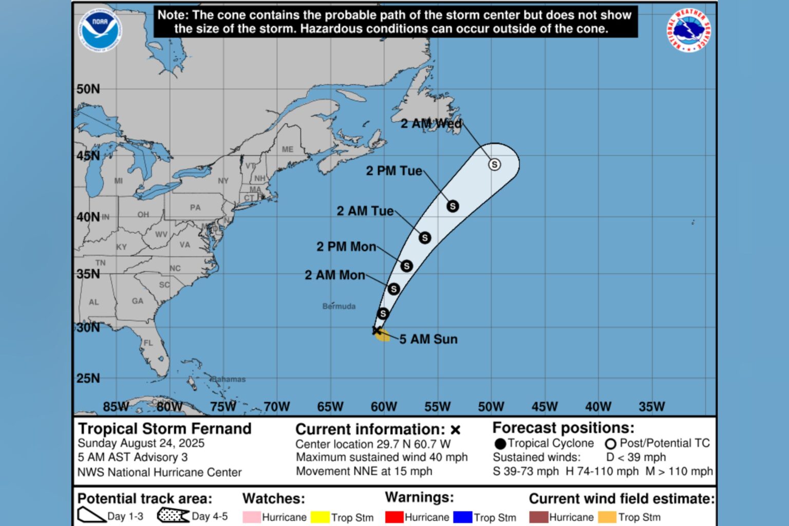
Tropical Storm Fernand is expected to track north-northeast over the Atlantic Ocean’s waters in the coming days, according to forecasters, after the system formed this weekend.
Why It Matters
Fernand is the sixth named storm of the 2025 Atlantic hurricane season.
It follows Hurricane Erin, which was the fifth storm and first hurricane of this year’s season. The system prompted warnings along the U.S. East Coast, where officials warned of life-threatening surf and rip currents.
What To Know
Spaghetti models—computer models that illustrate potential storm paths—suggested that Tropical Storm Fernand was expected to track north-northeast over the Atlantic.
Tropical Storm #Fernand (pronounced Fair-nahn) has formed, our 6th named storm of the season. It could near hurricane strength by Monday, but it’s forecast to continue moving north-northeast out to sea. It’s currently located about 405 miles SSE of Bermuda. @10TampaBay pic.twitter.com/UHgVZG6MPF
— Colleen Campbell (@ccampbellwx) August 23, 2025
In its most recent update on Fernand, the National Hurricane Center (NHC) said the system was moving toward the north-northeast at around 15 miles per hour, a motion expected to continue “over the next day or two.”
NEW: Tropical Storm #Fernand (fair-NAHN) officially forms. Could briefly become a Category 1 hurricane east of Bermuda Monday. Big surf again for cruisers to or near Bermuda early in the week, some swell into the Bahamas even too. No direct threat to Florida or the U.S. Next name… pic.twitter.com/iQVvThxrbf
— Noah Bergren (@NbergWX) August 23, 2025
This would be followed by a turn to the northeast, according to the agency.
“On the forecast track, Fernand should move well east of Bermuda and across the open waters of the subtropical North Atlantic,” it said.
The agency reported that maximum sustained winds were near 40 mph, with strengthening forecast during the next 48 hours, although a “weakening trend” was expected by Tuesday.
Meanwhile, the NHC was also tracking a disturbance with a 40 percent chance of cyclone development through both 48 hours and seven days.
“This system could become a tropical depression during the next day or two while it moves quickly westward at about 20 to 25 mph, passing through the Windward and Leeward Islands late today or tonight,” the agency said.
It was forecast to reach the central Caribbean on Tuesday, where conditions are likely to become less favorable for further development, according to the NHC.
What People Are Saying
Meteorologist Phil Ferro said in a post on X, Saturday: “Saturday Tropical Storm Fernand Advisory & Cone: No change in strength from the previous advisory, but could get better organized by Monday. The Forecast Cone shows it will stay far from land and eventually reach cooler waters by midweek. Should weaken by then.”
Meteorologist Eric Zernich said on X, Saturday: “Tropical Storm Fernand formed Saturday afternoon but it remains a very weak storm with winds up to 40 mph. Fernand could slowly strengthen over the coming days, but should stay way out to sea and away from the East Coast.”
The National Hurricane Center said on X, Sunday: “Fernand Continuing North-Northeastward Over the Open Atlantic.”
What Happens Next
Regular updates are issued by the NHC on its website and social media channels.
Read the full article here

