


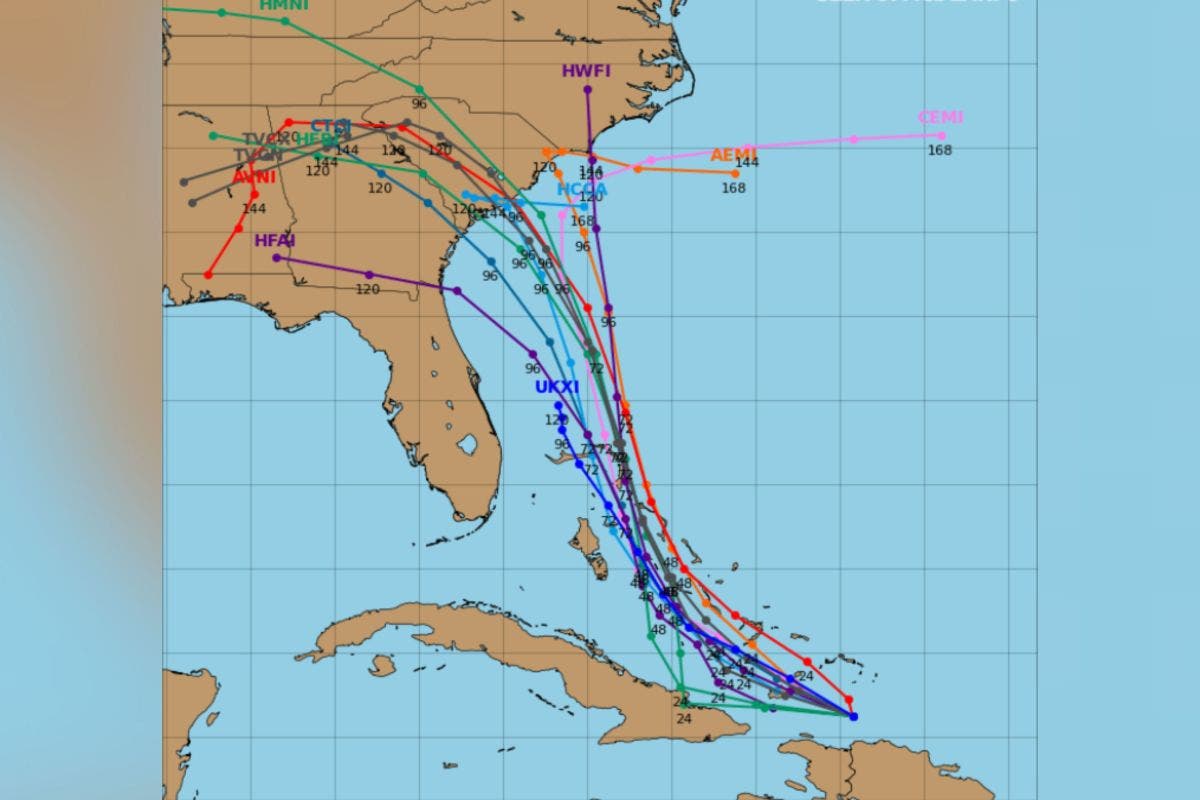
Spaghetti models—computer models that illustrate potential storm paths using meteorological data—suggested Invest 94L could potentially track toward the U.S. Southeast Coast.
Why It Matters
With Hurricane Humberto already churning, meteorologists have previously indicated that the Atlantic could soon see “twin hurricanes” and possibly a “Fujiwhara effect”—where two storms pivot around one another, if they draw close enough to interact.
If the Invest—a term used to designate an area of disturbed weather being monitored for tropical development—were to form a named system, it would take the name Imelda.
What To Know
In its most recent update on the disturbance, the National Hurricane Center (NHC) said that showers and thunderstorms were continuing to show signs of organization in association with a tropical wave near Hispaniola and the Turks and Caicos Islands.
“An area of low pressure is expected to form along the wave today when it moves near the southeast Bahamas,” it said. “This low is expected to become a tropical depression when it is in the vicinity of the central and northwest Bahamas later today or over the weekend, and then track northwestward or northward over the southwestern Atlantic.”
The agency said that regardless of development, downpours and gusty winds are ongoing in the Dominican Republic, Haiti, and the Turks and Caicos Islands and were likely to spread across the Bahamas and eastern Cuba in the days ahead.
“Interests in all of these areas should monitor the progress of the system. While there is significant uncertainty in the long-range track and intensity of the system, the chances of wind, rainfall, and storm surge impacts for a portion of the southeast U.S. coast during the next several days are increasing,” the NHC said.
The agency reported a “high” 80 percent chance of cyclone formation through 48 hours and 90 percent through seven days.
In a media advisory shared with Newsweek on Thursday, meteorologists at AccuWeather said the disturbance has the potential to become a hurricane later this weekend or early next week.
As for Humberto, the NHC said that as of 9 a.m. UTC on Friday, the hurricane was located approximately 465 miles northeast of the northern Leeward Islands, with maximum sustained winds near 75 miles per hour.
“Significant strengthening is forecast, and Humberto is expected to become a major hurricane this weekend,” it said.
What People Are Saying
Meteorologist Jeff Berardelli said on X, Thursday: “This is arguably one of the most complex steering scenarios in recent memory!! Two hurricanes(?), a stalled cut-off upper low, and a deep Greenland cold pool diving south.
“How all these factors interact with each other is driving the models… up the wall!! Will soon to be Imelda be pulled into the Carolina coast by the cut-off low as many solutions show? Or will Hurricane Humberto drag Imelda gradually out to sea, as Humberto gets dragged north by the large Greenland jet stream trough? Only time will tell, but folks from FL’s northeast coast to the Carolina’s especially should stay weather aware.”
What Happens Next
Forecasts are sometimes subject to change, with agencies such as the NHC issuing regular updates on their websites and social media channels.
Read the full article here


