


The cleanup operation is still underway after Hurricane Helene battered Florida recently, but now the state must brace for more misery with Hurricane Milton due to hit this week.
Milton, which is barreling toward the Sunshine State, looks set to be “a historic, once-in-a-lifetime storm for Floridians,” according to AccuWeather Chief Meteorologist Jonathan Porter.
Hurricane Helene, a Category 4 storm, left hundreds dead after hitting the U.S. on September 26. Experts say the latest hurricane, Milton, could also make landfall as a Category 4 storm, meaning winds of up to 156 mph potentially, while storm surges could reach up to 20 feet along the coast in the Tampa Bay area, depending on where and how the hurricane hits.
Flooding amid storm surges and heavy rains is a key concern when any hurricane strikes, but Florida is now particularly vulnerable. Protective sand dunes washed away by Hurricane Helene mean that there are fewer defenses than before, while the ground is already saturated in some areas.
In addition, damage caused by the previous hurricane has also resulted in a huge volume of debris, which will affect water flows and spark further destruction as fresh waters and winds hurl the detritus around the streets.
One of the most densely populated areas of the state, the I-4 corridor from Tampa to Orlando, is sitting in the predicted path of the storm, which is spinning toward the west-central Florida Peninsula.
Evacuation orders have already been issued for some barrier islands on the west coast, although many more are due to be issued. Kevin Guthrie, the Florida Division of Emergency Management’s executive director, said on Sunday: “We are preparing, and I have the State Emergency Response Team preparing, for the largest evacuation that we have seen most likely since 2017 Hurricane Irma.”
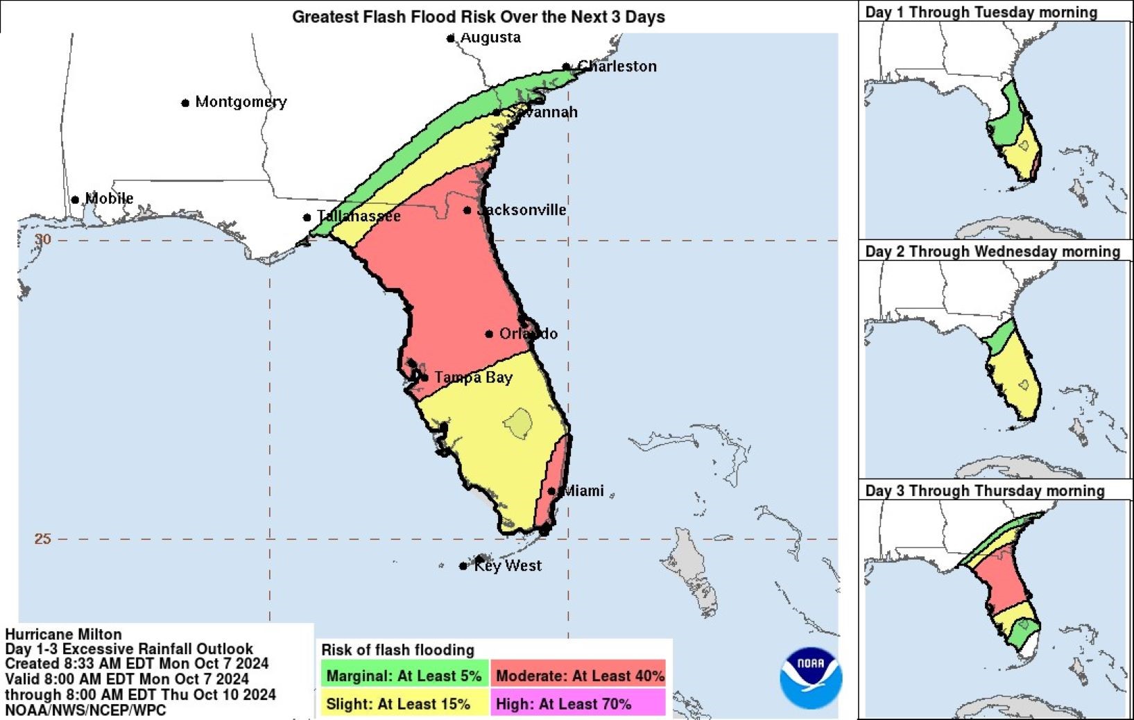
A color-coded graphic created by the National Hurricane Center shows the risk of flooding in Florida over the next few days, from Monday through to Thursday morning.
By Thursday, a slither of green indicates there is just a “marginal” risk of flash floods (around a 5 percent chance or more) at the top of the state up into parts of the neighboring states of Georgia and South Carolina.
Below that, a small section of “slight” risk (at least a 15 percent chance) is shaded yellow for northern Florida, with a huge swath of the central part of the state shaded red to show there is a “moderate” (at least 40 percent) risk of flash floods within the coming days.
The bottom half of the state is mostly at a “slight” risk, while a section of the southeastern part of the state, including Miami, is pushed into the higher “moderate” red-level risk of flooding.
Florida Governor Ron DeSantis said that the leftover destruction from Hurricane Helene could pose additional dangers in the face of a new storm: “There are some areas with a lot of debris… if hit by a major hurricane, it’s going to dramatically increase damage.”
Floridians should check their local weather forecasts for the most-up-to-date reports, monitor local safety alerts, and check whether their homes fall within an evacuation zone on the FloridaDisaster.org website.
Read the full article here


