


A dangerous line of severe thunderstorms is bearing down on Florida, with forecasters warning that parts of the state face an increased risk of tornadoes, damaging winds and heavy rain as a powerful storm system sweeps eastward across the Southeast.
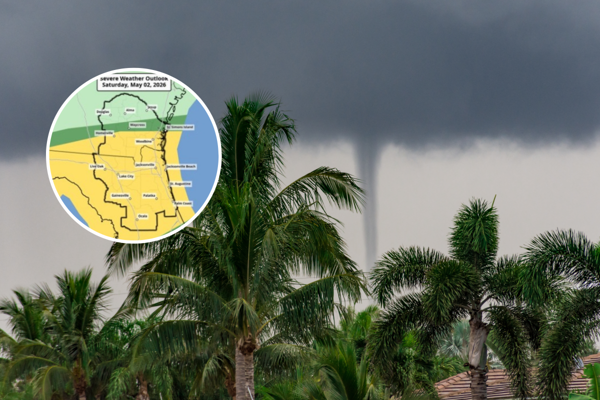
Maps from the National Weather Service (NWS) and the NWS Weather Prediction Center (WPC) highlight parts of northern and central Florida as areas of concern, with forecasters warning that a line of strong to severe thunderstorms could sweep from west to east, bringing damaging wind gusts, heavy rain and a risk of isolated tornadoes. The Day 2 outlook from the WPC shows the greatest risk concentrated across northern Florida and into the eastern Gulf Coast, as a low-pressure system interacts with warm, moist air already in place over the region.
The storm threat comes as much of Florida is grappling with worsening drought and heightened wildfire danger. In northeast Florida and parts of the interior, drought conditions are labeled as extreme and exceptional, the two most severe classifications on the U.S. Drought Monitor map, with meteorologists citing persistently low rainfall, dry vegetation and low relative humidity. These conditions have increased the likelihood of fast-spreading wildfires, with fire weather alerts remaining in effect across several counties.
“A widespread 1 to 4 inches of rain will go a long way in reducing wildfire risk, but it will not erase the drought,” AccuWeather senior meteorologist Tyler Roys told Newsweek. “Some areas are running a foot or more below the historical average for rainfall this year. Some fire zones may miss out on meaningful rainfall from this storm.”
Forecasters say the incoming rain could provide short-term relief for fire crews and help reduce immediate wildfire risks by wetting dry fuels. However, officials caution that while the rainfall is beneficial, it is unlikely to reverse the broader drought impacting the region. Long-term moisture deficits have built up over months, and meaningful drought improvement would require multiple widespread rain events rather than a single storm system.
Map of Impacted Areas as Storms, Tornadoes Possible
The approaching storms may produce frequent lightning, NWS Jacksonville said, strong wind gusts and brief tornadoes, particularly within a squall line expected to move through northern Florida. While tornadoes in Florida are often short-lived and weaker than those seen in the Plains, they can still cause significant damage, especially when they occur overnight or within fast-moving storms that give residents little time to react.
“The Storm Prediction Center upgraded areas south of Waycross to a Slight risk (level 2/5) for severe storms Saturday,” NWS Jacksonville posted on X on Friday morning with a map of the risk area. “The main hazard is damaging wind gusts, but there remains a low risk of tornadoes & hail. Timing: Southeast GA: morning Northeast FL: afternoon/evening.”
The broader weather pattern driving the threat involves a cold front pushing southeastward into a warm and humid air mass. This setup is favorable for severe thunderstorms and locally heavy rainfall, according to WPC analyses. Some areas could see rainfall totals high enough to cause localized flooding, particularly where dry ground struggles to absorb water quickly.
How Many Tornadoes Strike Florida Each Year?
On average, 46 tornadoes hit Florida each year, The Weather Channel reported, citing data compiled from 2003 to 2022. For context, Texas saw the most annual tornadoes during the years examined, with an average of 124, according to the report.
Florida Tornado Risk: What Happens Next
Emergency managers are urging residents to stay weather-aware and ensure they have multiple ways to receive warnings, including smartphone alerts and an NOAA Weather Radio. Tornadoes can develop quickly within intense thunderstorms and may occur with little advance notice.
As of Friday afternoon, there were no severe thunderstorm or tornado watches or warnings in place for the region.
While the focus is currently on tornado and severe storm potential, fire officials continue to stress that Florida’s wildfire season is far from over. Even after rainfall, strong sunshine, rising temperatures and gusty winds can quickly dry out grasses and underbrush, allowing fire danger to rebound.
Climate and drought outlooks suggest that above-normal temperatures will persist across much of the state, complicating recovery from the ongoing dry spell. As a result, forecasters say Floridians should be prepared for a volatile mix of hazards in the coming days, including severe storms, brief flooding and renewed wildfire risk once the system passes.
Officials recommend reviewing severe weather safety plans now, particularly for those in manufactured homes or areas prone to flooding, and avoiding outdoor burning during periods of elevated fire danger. The combination of drought-stressed landscapes and high-impact weather underscores the complex challenges facing Florida as it heads into peak storm and wildfire season.
Read the full article here


