

")


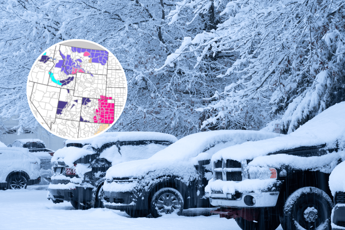
A late‑April winter storm is bringing heavy snow, strong winds and increasing avalanche risk to parts of the northern Rockies, with forecasters warning that mountain travel and backcountry conditions could rapidly deteriorate through Friday night and into Saturday.
The most severe impacts are expected across Montana, where multiple winter storm warnings are in effect, while the surrounding mountain regions of Wyoming and Idaho remain under winter weather advisories, according to the National Weather Service (NWS).
Forecasters cautioned that heavy, wet snow combined with gusty winds could make conditions dangerous both on roads and in the high country.
Montana
The highest confidence for disruptive winter weather is centered on central and southwestern Montana, where the NWS offices in Great Falls and Billings have issued several winter storm warnings.
In the Bears Paw Mountains and southern Blaine County, a winter storm warning runs from early Friday morning through noon Saturday, with snow totals reaching up to 9 inches above 4,000 feet and wind gusts as high as 50 mph.
Forecasters warned that slushy and snow‑covered roads, blowing snow and low visibility could make driving difficult, while heavy, wet snow may cause isolated power outages and tree damage.
Farther south, winter storm warnings remain in effect for the Gallatin and Madison County Mountains, the Centennial Mountains, the Crazy Mountains and the Absaroka/Beartooth Mountains.
Across those regions, additional snowfall of 3 to 7 inches, with locally higher amounts, is expected through Friday.
The NWS in Billings specifically warned that avalanche danger will increase in the Crazy Mountains and the Absaroka/Beartooth range, as heavy snowfall and gusty winds load existing snowpacks.
Forecasters cautioned that recreational travel in the high country could become increasingly hazardous, with periods of significantly reduced visibility due to falling and blowing snow.
Advisories Extend Beyond Warning Areas
Beyond the areas under winter storm warnings, winter weather advisories stretch across much of western, central and northeastern Montana, including the Little Belt, Highwood, Bridger, Castle, Big Belt and Sapphire Mountains, as well as surrounding valleys.
The NWS in Great Falls, Billings, Missoula and Glasgow warned of snow accumulations generally ranging from 1 to 6 inches, with locally higher totals in elevated terrain. Gusty winds could produce blowing snow, while wet roads may refreeze overnight, creating slick and icy conditions.
Advisories also cover much of northeast Montana, where snow showers, blowing snow and visibility as low as a quarter mile may affect travel, particularly during the Friday morning and evening commutes. Livestock impacts were also noted in some advisory areas.
Wyoming and Idaho
Winter weather advisories extend into northern Wyoming and central Idaho, mainly affecting mountain passes and higher elevations.
The NWS in Billings issued an advisory covering the Pryor and northern Bighorn Mountains in Montana and the northeast Bighorn Mountains in Wyoming, warning that snowfall of 4 to 8 inches could lead to near‑whiteout conditions at times, particularly along U.S. Highway 14.
In Idaho, the NWS in Missoula issued advisories for Lemhi County and the southern Clearwater Mountains, where valley snow totals of 1 to 3 inches could increase to 5 to 10 inches at pass level, with more than a foot possible in the highest terrain.
Hazardous travel conditions are expected over mountain passes through Friday morning.
Read the full article here


